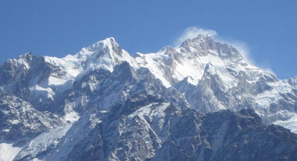
Kanchenjunga trek takes you to the lap of the third highest peak of the world in Mt. Kanchenjunga (8586m). Kanchenjunga is situated to the far northeast of Nepal and bordered with Sikkim, India. The mountain of Kanchenjunga was assumed to be the highest mountain in the world until 1852.
Kanchenjunga Trekking is best trip for those prepared to devote time and energy required to complete this route to the Nepal side of Kanchenjunga. This trekking is undoubtedly one of the rewarding walk in the entire Himalaya. Straddling the border with Sikkim in the remote northeastern corner of the country, the massif is the third highest peak on earth afterMt. K2in Pakistan- one of the most formidable world’s 14 eight-thousand meter summits. Steep and narrow trails, magnificent forests, utterly breathtaking mountain vistas, few settlements and a real sense of wilderness characterize this corner of Nepal. This approach route cuts across the grain of the mountains, crossing a series of ridges of increasing height before following the valley of the Simbuakhola into the awesome amphitheater formed by the south wall of Kanchenjunga.
Kanchenjunga trekking was first opened to trekking parties in 1988, the very inaccessibility of the Kanchenjunga Himal deters all but the most avid mountain enthusiasts. Trekker parties must be self-sufficient in every respect. Provisions are all but unobtainable beyond Taplejung. And the services of a competent trekking outfitter are both a legal requirement and a matter of common sense.
First arriving at the Suketar airstrip above Taplejung involves one of the most hair-raising landings imaginable. On the final approach Kanchenjunga sways alarmingly back and forth through the windscreen of the Twin otter, as the pilot fights the air-currents to keep the plane level. One second you are cruising high above the Tamur valley, the next you touch down on a postage-stamp landing-strip with mountainside falling away from it on three sides
Kanchenjunga Base Camp Trek
Lukla may be famous, but its way behind Suketar in adrenaline stakes. Taplejung to Ramze Flights into Suketar operate early in the morning, so you’ll probably want to set off the same day. The path heads northwards along the top of the ridge for a couple of kilometers before dropping east into the valley of the Phawakhola. At a colourful collection of Shiva shrines in the forest just before the main trail drops away Bara (3794m). A small Shiva temple stands on top of this forested hill to which Hindu pilgrims come from all over Nepal-if you have time, join them and spend an extra night sleeping out up there.
Memories of the sunrise views of Kanchenjunga, Makalu and Lhotse first camping place on the main route-reached after about three hours-is the primitive settlement of Lalikharka, where you can pitch your tents on some disused terraces from here the next night’s camp is visible on the clearly defined notch in the ridge to the east across the Phawakhola, at a place called SinchewaBanjang.
The going is immediately strenuous, as the trail descends steeply to cross the river via a small sus-climb up the other side. The villagers hereabouts are scattered settlements of beautiful thatched farmhouses, with colourful flower gardens shaded by poinsettia trees, pumpkins ripening in the sun and corn hung to dry under the eaves. Khunjuri, about an hour up from the bridge, makes a good lunch spot as there are several enormous papal trees affording delicious shade. There are stunning views to the entire Kangchrnjunga massif from the camp at SinchewaBanjang. Make the most of them, for you will not see the main peaks again until you round the corner of the yalung glacier above base camp at Ramze, though jannu makes sporadic appear-ances along the way. From sinchewaBanjang the trail contours gradually around into the huge valley of the kabelikholafor two days to reach Yamphudin (1650m/5414ft), the most remote settlement on this route, with plenty of steep ups and downs as it crosses tributary streams.
The terracing of the rice paddies around here is quite incredible, and care should be taken to stay on the correct path as it weaves its way through a vast tapestry of tiny emerald-green fields. Camping sites are hard to find between Sinchewa and Yamphudin, as every last piece of horizontal ground is planted with rice. The school-yard at Mamankhe village may be your only option, and it will not be a peaceful night. The next day, as the trail descends across steep open hillsides to approach Yamphudin, it finally meets the river, and an hour before the village crosses the Omjekhola debouching from its fearsomely steep and densely forested valley to join the main stream. This is a wonderful place for a combined lunch-stop and Jacuzzi session- the last opportunity for ablution that does not entail potential hypothermia for at least two weeks. The second half of the walk-in really is a contrast to the first. Above Yamphudin the tiny trail climbs a brutally steep ridge to a single farm-house commanding fine views over the country traversed so far. It continues upwards in dense forest before crossing the DupheBanjang and descending into the upper Omjekhola valley, where you will probably want to spend the night camped by the river.
The final obstacle between you and the Simbuakhola valley is immediately above you now, and it’s a steep, waterless climb to the crest of the DeoraliDanda ridge at LamiteBanjang (3235m/10599ft), best tackled early in the morning to avoid the heat. Given clear skies, jannu is visible from this ridge. The descent into the wild coniferous woodlands of the Inbuakhola commences with an airy traverse of some steep screes-a place to watch your feet! Abruptly the entire environment changes as the trail plunges down from the col. At the head of the valley lies the Yalung Glacier, and at sunset the temperature plummets as the cool air from above sinks to the valley floor. The last few days to Ramze camping at Dorondin and Tseram amongst towering, lichen-swathed pine trees and by rushing glacial streams, are simply idyllic. More rugged now, the path follows the boulder-strewn riverbed, ascending steeply towards the snout of the glacier.
The flora becomes increasingly alpine and sparse and the valley opens up gradually to reveal stunning vista of snow- capped Himalayan peaks. Koktang (6147m/20168ft), Ratong (6678m/21910ft) and Kabru (7353m/24125ft) from a scintillating hori-zone ahead as you enter the ablation zone above Tseram and stroll along through golden grasslands into Ramze. There is a single stone hut at Ramze which is invariably locked, and though it may be tempting to continue further on this easy trail, the last water is here and you should pitch camp. Spend a day resting to acclimatise for the days ahead, and to allow time to gape at the scenery. Ramze to Pangpemathere are two options for the next stage of this trek, which takes you across the southern flanks of Boktoh peak to the Ghunsakhola and thenorth side of the massif.
A higher north, via the 5250m (17225ft) Lapsang La, is strenuous, takes two long days, and yields only partial views of KANGCHENJUNGA and Jannu. The lower, more southerly route rec- Ommended here, via the La 4500m (14765ft) Sinelapche La and the 4400m (1436ft) Margin La follows a better before camp. The phenomenal north face of jannu rears up above the head of this serpent of corrugated ice like a hooded. Apparition,its vertiginous cliffs cold sinister in perpetual blue shadow. Away to the north leads the Dakhunapokhola, beneath the jagged bastions of the SharpuHimal (6236m/ 20460ft) and Nupchu (6690m/21950ft). An extra day’s hike up this valley is worthwhile, as is a back across the river and onto the moraine of the Jannu Glacier. Above Kambachen you enter an area of pure Himalaya mogic. Leaving the tiny settlement past a cluster of fluttering prayer flags, the path crosses an open mountainside and finally enters the old ablation zone of the Kanchenjunga Glacier at Ramtang. From hate the intimidating north face of Kambachen (7903m/ 2593ft) briefly appears up a side valley to the south, and there are scattered roofless stone huts that provide good shelter for cooking lunch.
Yaks graze on the sparse golden grass, the sound of their bells rising on the cold wind. Camp is at Lhonak, the coldest night on the entire trip as the wind rips across this huge open space and chills you to the bone. From here a trail heads north over the Chabuk La (5682m/18643ft) into Tibet which is still used today by the Tibetans you will meet at this desolate, airy place, Arriving midafternoon, do not be tempted to pitch your camp on fine, level plain- choose a spot up on the fine, level plain- choose a spot up on the moraine or tucked under the cliffs. The reason should be apparent from the qusk the herds return, thousands of snorting, bell-donging animals; bull yaks do not step daintily over guy-lines! The sheer scale and grandeur of the mountain world you now find yourself in defies superlatives, and the final easy hike to pang pema is a walk to savor all the way.
Ahead, Nepal peak, the twins and tent peak notice you onward, but to the south across the glacier it is the lesser wedge (6750m/22147ft) that really draws the eye, with its exquisite fluted summit. Until just before pang pema that is, when suddenly the incredible north face of Kanchenjunga itself looms into views. Pang pema is a place to just sit and relish the mountain prospects. Those seeking an head off up the slopes immediately behind pang pema to drohmori, from the cairned summit of which- at 6200m(20342ft) – you can see the entire Kangchrnjungahimal, jongsang peak and the mountains from the border with Tibet to the north, and even makalu on the horizon to the west. Walk – Out Taplejung to Suketarending.
First we welcome you to home of Mt. Everest, Nepal, country of Himalayas. Upon arrival at Tribhuvan International Airport our representative will welcome you and assists to transfer to your hotel in Kathmandu. You will have to make rest day in Kathmandu. Make permit day and you can look around in Kathmandu valley or make Sightseeing tour in the Kathmandu valley. After time to get refreshed, evening you will meet and transfer for the welcome dinner in any comfortable restaurant in Kathmandu and short briefing about your trip and overnight hotel. We meet early morning and start our trekking trip.
Today you will take early morning flight from Tribhuvan International Airport (TIA), Kathmandu to Biratnagar airport, Biratnagar, the second largest city after Kathmandu situated to the southeast of Nepal. The flight takes about 45 minute. Overnight at hotel.
Today you will take 45 minute flight to the airstrip at Taplejung Airport, Taplejung. It is situated to the northeast of Nepal. We will meet our porters and the rest of the trek crew here and we spend the night either at Suketar or Taplejung. Suketar isonly 2/3 hour walk from the airstrip. In the event of bad weather, it is possible to drive to Taplejung for overnight stay at hotel.
Today is our actual trekking day and the first day of trekking is short along the downhill. It's a 3 to 4 hour walk to Mitlung, crossing the HungdewaDhola to arrive beside the raging Tamur River. Mitlung is a small farming village surrounded by paddy fields. Overnight at hotel.
From Mitlung, the trail climbs out of the village before dropping down to Sinwa after a couple of hours. Sinwa is a well-kept village with a large school. Bananas, grapefruit and oranges are grown here. We continue to a pleasant lunch spot at Tawa then climb up again before crossing a suspension bridge at Thiwa, where there are great views up the valley. Finally we arrive at Chirwa, where we camp on a large field on the far side of the village, surrounded by water-worn boulders.
From camp the trail leads uphill for 30 minutes until the valley broadens out and we drop down to meadows. After showing our trekking permit at the park gate, we cross the river onto the west bank and follow a newly built path through delightful forest - look out for butterflies, dragonflies and praying mantis. The path is flat for an hour before we gain height and contour the steep hillside above the river. We have lunch looking out across the valley. In the afternoon, we drop down via indistinctive paths to cross the Tamur River for the last time where it is joined by the Ghunsa Khola. After another 20 minutes we arrive at Sekathum, a campsite and lodge right next to the river.
We have our first views of Jannu from the campsite if the weather is clear in the morning. It's a tough walk today, following a new path, which is very narrow in places, undulating, exposed and slippery after rain. We cross the river directly out of camp over a new bridge and follow a path steeply up and then down, before soon crossing back over the river on an older wooden bridge.
Again we climb up out of the bottom of the gorge and then drop back down, passing a solitary lodge at Solima until the trail descends right down to river level. For a few hundred metres the path clings to the side of the gorge, with spray from the pounding river making it all too obvious that a slip here would be catastrophic. Further on we cross the river once more to a lunch spot. After lunch we follow zig-zags up through trees until the path contours high above the gorge. Eventually we reach Amjilosa, a collection of Tibetan lodges high on the hillside above the gorge.
From Amjilosa the trail contours the hillside before dropping down through bamboo, oak and rhododendron forest. It's undulating and narrow with the odd exposed section, though any sense of exposure is removed by the presence of the bamboo. Eventually we reach a small stone house by the river before climbing up again. The path crosses a couple of small bridges at the base of waterfalls. Lunch is at a great spot by an icy pool at the base of yet another stunning waterfall. It's a short walk in the afternoon uphill to Gyabla, a small Tibetan settlement with impressive views up the valley towards Khabur The air here feels much cooler and we have the sense of entering the high mountains.
After putting on some warmer layers of clothing we set off and drop down to the river yet again. After 1.5 hours we arrive at 3,000m and enter Larch pine. The path now becomes very easy underfoot and the valley begins to open out. We arrive at Phole (3,140m) for lunch. Phole is a fair sized Yak herder settlement with a rather run down Gompa. It's another 1.5 hours trekking to Ghunsa, a Sherpa village, which benefits from a small hydro-electric power plant. We will camp outside of one of the Trekking lodges here and look forward to two nights in this relaxing spot.
In the morning we can do some washing and have a chance to sort out our gear before having an acclimatisation walk. The walk heads up towards the Lapsan La through forest to a point above the tree line at c4, 200m. We should be back in Ghunsa in the early afternoon to relax and have a shower. You can make a phone call and even send a postcard from here.
Heading north from Ghunsa the trail follows the east bank of the river. It really is delightful walking through Larch and Juniper, with some trickier sections across small landslides and along the riverbed. We cross a bridge at RampukKharka (3,720m) and have lunch just beyond against the backdrop of snowcapped peaks and spires. In the afternoon we continue on past a sacred waterfall before contouring up the hillside and crossing a large landslide. It's important to move quickly across this hazard as there is always the danger of stonefall from above. Just beyond the landslide we have our first views of Jannu, as it comes into view above a ridge. It is simply breathtaking and consequently, it may take us a while to walk the last section into Kambachen (7 hours).
It is possible to continue to Lhonak (4,785m) today, but this would be pushing our acclimatisation schedule and would likely result in some members of the group suffering from the symptons of altitude sickness. Instead, we will base ourselves from Kambachen as there is plenty to see and do from here as part of an 'active pottering' day. We will most likely walk up the Nuphchu Khola Valley for superb views of Jannu. It's also possible to trek up towards Jannu's base camp, though the Ghunsa Khola can be difficult to cross so this might not be the sensible option. Having had a second night in Kambachen, we should find the walk up to Lhonak tomorrow fairly steady and crucially, the long day to base camp the following day will feel easier for everybody.
From Kambachen, the trail follows the hillside on the north bank of the river. At a waterfall, the base of which can sometimes be icy, the path almost disappears and there is a section of boulder hopping. We cross a bridge and climb up to Ramtang, a grazing pasture with a couple of Yak herder huts. It takes another hour or so to reach Ghunsa. At first, we amble along gentle paths, which weave between boulders, taking in the superb views.
Not long before we arrive at Lhonak the path is narrow and loose where it crosses some small landslides, before dropping down to the river and finally arriving at Lhonak. Here there are 6 Yak herder huts set out on the expansive and grassy valley bottom. Chang Himal has now come into view ahead and the route beside the Kangchenjunga Glacier all the way to Pangoema is visible.
It's possible to visit Pangpema and return to Lhonak the same day, but this wouldn't be much fun. Instead, we can take as much time as we like to walk the final 6 miles to base camp. The trail follows the edge of the glacier all the way and is mostly fairly gradual on grassy trails. There are some rockier sections and a couple of narrow landslides, which need to be crossed quickly.
Chang Himal looms over our right shoulders all morning with its steep North Face - first climbed in October/November 2009 by Brits, Nick Bullock and Andy Houseman - and at the head of the valley is KiratChuli (7,386m), a peak attempted in 1985 by Jagged Globe Managing Director, Simon Lowe. Pangpema is a flat, grassy base camp with a couple of porter huts. For better views of the vast bulk of Kanchenjunga's North Face, we can walk up a little higher above base camp to a natural viewing platform.
There's no rush to descend back down the valley, so those who would like to take more photos in the morning light can do so. The sun casts shadows across the north faces at this time of day, so really it's a better time for photography. When we are ready, we will stroll back to Lhonak and then continue down the valley to Ramtang, looking out for Blue Sheep on the steep mountain sides. We can camp here in a beautiful spot, which has the advantage of getting the evening sun until relatively late. Alternatively, we can continue on to Kambachen and have a shorter walk to Ghunsa tomorrow.
The return walk to Ghunsa from Ramtang look Round and come to Ghunsa.
The trail out of the village passes the hydroelectricity plant and soon climbs up into the dense forest of moss, Rhododendron and juniper. After 45 minutes it becomes extremely steep and for the next hour, it's a tough ascent up rocky steps to emerge from the trees at a point on the ridge. The path now crosses onto the south side of this ridge and contours across the hillside to a possible lunch spot by a stream, just before a short pull to reach a saddle at 4,210m. It's another 20 minutes or so to arrive at Sele La, a small camping spot by a hut and bubbling stream surrounded by lichen-covered boulders.
This is a long and demanding day, but also one of the most rewarding on the trek. There are superb views and the walking over three high passes is both varied and continually interesting. From camp, we slowly climb up to the first pass, the Sinion La at 4,480m. The views from here of the south side of Jannu and the East Face of Makalu are incredible. Cho Oyu can also be seen in the distance.
We then contour two corries, crossing the Mirgin La (4,480m), then dropping down, before walking on rocky paths to gain the Sinelapche La (4,724m). If it is clear, the views from here into Sikkim and towards Ratong (6,675m) are fabulous. The 850m descent to Tseram is a test of the knees, being very steep and to begin with, loose and shalely underfoot. The trail drops down to a small lake, then descends extremely steeply to Tseram (7 - 8 hours).
As we're now very well-acclimatised, the walk to Ramche and onwards to the viewpoint of Oktang should not feel too demanding. We are soon above the tree line and climbing up through alpine meadows, beside a stream. There might be a few icy sections underfoot and it's common for the lake at Lapsang to be frozen. We follow the lateral moraine of the Yalung Glacier to eventually reach Ramche after 3 hours or so. It's a lovely, grassy spot and there is a new porter lodge here.
We'll have lunch before ambling on in the afternoon up the open valley to climb right up onto the edge of the moraine to reach a Chorten at Oktang (a further 1.5 hours). The climbers' base camp for the north side of Kangchenjunga is another day across the glacier, so Oktang is the logical high point, which can be reached without ropes and mountaineering equipment. We descend back to Ramche in the late afternoon to enjoy the surrounding mountains turning from gold through to pink as the sun bathes Ratong and Kokthang with evening light.
It takes a couple of hours to walk back down the valley to Tseram. From here, we continue on down the valley beside the Simbuwa Khola to Torontan. Much of the afternoon is spent in the cool of the forest, with sections of the path close to the riverbed. There are three Teahouses at Torontan perched above the river and some nice terraces for camping (6 hours).
From Torontan, a bridge crosses the roaring Simbuwa Khola. At first we follow the left bank of the gorge, before the path begins to ascend above the valley through the trees. It's fairly hard going all morning as we climb higher and higher through the forest. A huge landslide in this area means that the trail now ascends to almost the top of the ridge and the saddle called 'LasiyaBhanjyang'. The final section of trail is cut each year (following the monsoon) through the trees and in places literally requires you to pull on branches to ascend the steep mud.
At the top of the pass there is one hut - Lassithan, where we can stop for a well-deserved rest and lunch. Then, it's a big descent down the other side of the mountain. Eventually we arrive at a river, hop across this, then contour for another hour to another impressive river and rickety bridge. A further hour sees us walking into Upper Yamphudin, a beautiful Sherpa village with Trekking lodges. Congratulations on completing one of the toughest days on the trip! (8 - 9 hours).
In the morning we will drop down to the lower village and the river, as this is a good spot to wash, camp and for everyone to have a day off.
We descend from Yamphudin to the Kabel Khola and climb to Ponphe 5,500 ft. for our camp.
Today, we start to climb to a ridge then descend through a series of side valleys past Phudin village to Kesawa. The trail continues to ascend to a Gurung settlement at Bhanjyang. From here the trail circule a ridge and descends to the Limbu village of Khunjari, where we camp on the banks of Pha Khola and overnight at camp.
Today, we'll have the last day after long trek and an easy walking down to the SuketarTaplejung and overnight at camp. As a last day we celebrate the dinner with crew member and enjoy the evening after completion the long and adventurous trek and overnight at camp.
From Suketar we flight back toBiratnagar and flight back from Biratnagar to Katmandu direct flight depends on the flight schedule and season. We will come to Kathmandu and transfer to your hotel and remaining time simply rest and relax at the hotel.
Rest and shopping day in Kathmandu, evening farewell dinner
See you again wonderful Himalayan country in Nepal. Today is free or last minute you have few hour special shopping for your friend and family to gift, relatives for you until your departure flight to your home country. Or any extra trips or activities you may have booked with us. If departing, you will be transferred to the International Airport for your departure flight to your home country. Hope to see you again Nepal Himalayan country.
Enjoy the popular trekking and tour packages in Nepal Himalayas. 2024.
© 2011 - 2024 All rights reserved. Himalayan Sustainability Initiative Trek Developed By : Xenatech Nepal